A valley for all Seasons
Eskdale has a plethora of paths, lanes and bridle ways to explore, the valley is home to one of the most picturesque rivers in Britain, with easy paths to follow and plenty of welcoming hostelries. For the experienced walker and climber the options are almost endless, with access to some of the best mountains in England. Eskdale provides a challenging environment for the mountain walker, with technical rocky fells, steep climbs, traverses and ghylls to scramble up!
This page is a collection of local favourites to whet the appetite, the real fun is in discovering the area for yourself so don't be a stranger come and visit Eskdale!
Editors favourite:- Scafell from Brotherilkeld
This is a good days walk which can be extended by starting from Dalegarth/Boot if transport to the top of the valley is not available. A map is essential as route finding may become difficult in adverse weather. In wintery weather some parts of the route are steep and an ice axe or crampons should be considered although the route is neither a climb nor particularly exposed.

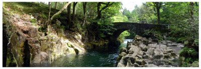
Park at the foot of Hardnott Pass, not at the phone box as this hinders the farm vehicles turning into the farm but just a little higher up over the cattle grid is a fair sized parking area. Follow the path to Brotherilkeld farm and on up the valley, the path stays close to the river for a time. Look out for the Eskdale Needle on the right, it is not easy to spot and often missed due to the tremendous view of the fells directly ahead, The river is crystal clear and has many deep pools ideal for a dip in summer. After about 3km Lingcove Bridge is reached, an ideal opportunity for a photo and short rest. The path crosses the bridge over Lingcove Beck and rises along side the Esk Gorge (excellent scramble in summer). The Great Moss is soon reached, this is a large boggy area, the path follows the river for another 1.5km then soon after the giant Samson stones are passed on the far side of the river, cross over to reach the foot of Cam Spout crag. Cam Spout is the waterfall on the right of the crag, the path rises sharply along side the waterfall, care should be taken here especially in winter. Follow this valley until the foot of a daunting crag appears directly ahead, just before reaching the crag a steep gill cuts of to the left, this is the last such gill before the crag. Climb the gill, scrambling over slippery rocks, this can look a bit unlikely in winter but proves easier than it looks. The path pops out of the gill into a small corrie containing Foxes Tarn. From here follow the path north west to the col then south west for the summit.
Descend down the Long Green onto Slight Side, to return to Boot head for Stony Tarn and Eel Tarn otherwise head for the top of Cat Cove Beck and Scale gill then on down to Taw Hause, over the bridge and back to Brotherilkeld. Total
Distance about 16km and approx. 900m of accent.
Favourite Walks - Chris Jones
In the introduction to Wainwright's book 'Walks From Ratty' the famous chronicler of the Lakeland fells says this about Eskdale - 'It is the finest of all valleys for those whose special joy is to travel on foot and a paradise for artists.' The following six walks are a starter pack of personal favourites, starting with three that are, virtually, on the flat.
Along the banks of the River Esk
This walk follows the wooded path from Dalegarth Hall to Doctor Bridge beside the loveliest and most varied stretch of the River Esk.
Start at the car park by Trough House Bridge, or from the station at Dalegarth. Shortly after passing Dalegarth Hall you will come to an open crossroads of bridle ways. Turn left here, cross the narrow wooden bridge and the broad path will guide you straight to Doctor Bridge. Cross over and follow the opposite bank back as far as St. Catherine's church. Walk up the lane a little way, and then take the walled path, crossing the fields, to Trough House Bridge.
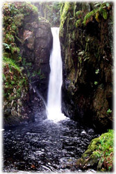
Stanley Ghyll Force
A two mile walk through woods and a ravine with the final reward of one of the loveliest waterfalls in Lakeland. The walk has the same start as the riverside walk, above, but, instead of turning left, cross the opening to a gate in the left hand wall which leads into Stanley Gill Woods.
The Eskdale Green Round
An ideal stroll if you are staying in Eskdale Green, with a wide variety of scenery and views. Being a circular route there are a number of starting points, but I have taken the car park at Forge Bridge. Take the sign posted track up to Milkingstead. Cross the Esk at the first bridge and follow the field wall to Fisherground. Keep to the left of the farm buildings, over the Ratty line and on to the fell path that heads up to the Outward Bound's wall. A gate at the top brings you to a track called Smithybrow. Turn right, down through Low Holme's gates, to the narrow Miterdale road. Go left and presently you will pass the bobbin mill, a farm and the school. At the main road turn left and then right towards Irton Road station. Carry on over the bridge, along the lane to Forest How and on over to Muncaster Head Farm. Turning left the track leads you back to Forge Bridge.
Blea Tarn
The tarns of Eskdale are quite diverse in character - from the tiny pool that is Fox's Tarn, high on Scafell, to the vast mirror of Burnmoor Tarn. Of all of them, though, Blea Tarn is the most immediately attractive. It nestles high on the granite shoulder above Boot and, while the path is steep, there are ample excuses to pause and admire the view. Start the walk at Beckfoot, a stop on the Ratty, or a short walk from Dalegarth. Cross over the railway line and head up the grassy path. After a short while the path turns left and proceeds as a series of zigzags up the side of the fell. Sooner than expected you are high on the shoulder with Blea Tarn sparkling at your feet.
Upper Eskdale from Silverybield CRAG
Now little known or used, this route follows one of the oldest paths to Upper Eskdale and Esk Hause. It is rather like being 'backstage' at Eskdale's grand theatre. There are crags, becks, dubs and mosses but with no semblance of order. Then suddenly, at Silverybield Crag, you will find yourself transported up to the 'gods' with the full glory of the Scafells and Upper Eskdale unveiled before you. The walk starts at Taw House where a farm track leads to the bridge at Scale Gill. A steep zigzagging track will leave you breathless but the rest of the route is quite gentle. At the top the path heads north-west, skirting Damas Dubs until, after a final rise at Silverybield Crag, the view unfolds. When you run out of film return by the same path.
Low Birker Tarn
The low fells and outcrops that border the valley, to the south, from Harter Fell to Stanley Gill are seldom visited by walkers. This is the final fling of the volcanic rocks that make up the massive crags of Scafell and Bowfell. Here, on Green Crag and Crook Crag, the outcrops share the same qualities but are more accessible. Start at the Woolpack Inn and cross the Esk at Doctor Bridge. Turn right up the bridle path as far as Low Birker and then take the grassy footpath to the left. This climbs up the slope, between juniper bushes, until a fell gate is reached. The path heads up steeply to the right before easing into a gentle traverse to the lip of Birker Force. Low Birker Tarn is now only a few minutes away and the rocky crest of Crook Crag is in sight. In fine weather, skirt Tarn Crag, to Kepple Crag, and down to Penny Hill Farm.
The Woolpack Walk
Distance - 30 KM (18.75 miles) Ascent - 2040m (6700ft) A full days walk - Free pint in the Woolpack Inn for completion in less than 9 hours.
MAP: The English Lakes - South West Sheet 1:25000 or OS Sheet No. 89
A superb walk encompassing Scafell, Scafell Pike, Broad Crag, Esk Pike, Bow Fell, Crinkle Crags, Hard Knott and Harter Fell in a hard but very satisfying high level circuit around the upper Eskdale Valley

Start from the Woolpack Inn early in the morning and head north east to Stony Tarn slowly gaining the feeling of more and more isolation from the valley. The walking is easy but navigation not so (keep to the edge of the large flat marshes) the landscape draws you into it and enshrouds the view until you stumble across Stony Tarn, hiding in a westerly bowl. After topping up water bottles pass the tarn on the north west side and continue in a more northerly direction to attack the steep blunt nose of Slight Side.Keep to the higher ground above the plateau of the Cow Cove tributaries and don't expect to see Cat Cove Tarn, it doesn't really exist any more due to extensive vegetation now creeping towards it's centre. Time for a quick break after climbing Slight Side and a first real chance to observe Wasdale, Eskdale and the beauty and uniformity of the upper Esk landscape.
Continue more steadily to the summit of Scafell, each step revealing the beauty of what lies below. To the southwest is Mitredale, a little visited valley with Burnmoor Tarn at its head. To the east the whole of the Woolpack walk can be seen threading it's high route over the summit and col to the spines of the Crinkle Crags before it's descent to the lower confines and security of Hard Knott and on!
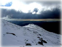
A decision has to be made on Scafell, Broad Strand is not recommended without a rope and knowledge of how to use it correctly (hire a guide), still challenging and thought provoking is Lord's Rake to the west. The easier and more direct route from the summit is descent via Foxes Tarn (a useful watering spot on a summers day). From whichever descent is used, gain Mickledore, location of a Mountain Rescue Wooden Box. Now the ascent can begin on England's highest Summit, Scafell Pike (977m). Keep zigzagging up through the rocks until on the summit. From here in the west is Wasdale, with the Isle of Man in the distance. Northwest reveals the Solway and Galloway peninsular of Scotland, north is Skiddaw, and northeast is Helvellyn. Windermere can be seen snaking along its length in the west and southeast shows the Old Man of Coniston.
Once you have appreciated this 360 degrees panorama to the fullest, descend steep scree to Broad Crag Col. From here Broad Crag itself is only a couple of contours away and only a slight deviation off the path. Rejoin the good flat path to arrive at Esk Hause, one of the Lake District's best known cross roads between Eskdale, Langdale, Borrowdale and Wasdale, also the home of some bad navigation errors in bad weather.
Scramble southeast to the standing boulders atop Esk Pike and down to Ore Gap, easily recognised by the colour of the earth and the rocks surrounding it. Bow Fell is an easy walk from here except for the scramble up the last 20-30 metres to the real summit with plentiful large boulders to provide shelter from any wind direction. The summit commands superb views down Langdale and onto the Langdale Pikes and the view to the west brings a smile as you can virtually see all the route done so far.
Care must be taken in descending to Three Tarns. Do not head south too soon as the Bowfell Links gullies are difficult, loose and steep. The correct descent is well cairned, but even this is steep and loose in places.
The ascent of Crinkle Crags meanders across, many different paths, no one any better than the others. Can you spot the Woolpack from here?
There is a bad step at the at the southern end of the main summit, but it is not severe and can be avoided easily to either side, or by scrambling underneath (without a rucsac). The step itself involves a 3 metre vertical wall with a jammed boulder at it's top (it is descended from the north). You can leave the ridge after several hundred metres and head for Stonesty Pike or Adam-a-Cove. From here, traverse down carefully through rough fell and broken scree to arrive at the head of Mosedale. Major summits are now over and Hard Knott is a pleasant amble on firm ground. The route passes near to Eskdale Needle, an impressive tooth of rock sticking up from the fell.
Weave your way from the summit of Hard Knott steeply down to the crest of the famous pass and then more gently on and up to Harter Fell, whose summit never seems to arrive, each false summit revealing another, until eventually you are stood on the top and have a chance to survey the whole of your walk now that there is only descent left to go. From Harter, Fell, the highest point in the valley, a straight line can be seen down the River Esk to the sea at Ravenglass. In the south, the Duddon valley does the same.
A sumptuous feast at the Woolpack Inn should now be beckoning. Head west and then descend the old miners track to Penny Hill Farm before walking along the flat valley floor to cross Doctor Bridge and then return to the Woolpack Inn for much needed refreshment.
Muncaster Fell - Christine Thornley
The walk described here, making use of the Ratty Railway ( a treat in itself ), is from Ravenglass to Eskdale by way of Muncaster Fell. Although the walk can be taken in either direction this way gives the most spectacular views ahead.
From Dalegarth Station, or Irton Road Station (which would shorten the walk by about two miles ) take the Ratty to Ravenglass.
There is a mile or so of road walking from the station along the A595 towards the entrance and car park of Muncaster Castle. At the bend in the road there are two bridle paths on the left. Take the one sign posted to Eskdale which is a track of Roman origin, known as Fell Lane and edged by old walls and much vegetation.
Continue upwards until the rhododendron grove is reached, where Muncaster Tarn, although half-hidden by trees can be seen on the left. Go through the wicket gate past the fence enclosing the young trees on the left. It is from here that the magnificent panorama of the western fells begins to unfold. The path veers to the right to avoid Hooker Crag - the highest point of the ridge. A detour to the top of the Crag will award the climber with glorious scenery in all directions ( apart from the intrusive aspect of the power station at Sellafield ). Westward is Ravenglass, the estuary where the River Esk meets the sea, and the Isle of Man, and in the other direction the upper Esk, Scafell, Miterdale and the Coniston mountains.
Continue along the path to the raised stone slab inscribed ' Ross's Camp 1883'. Supposedly this monument ( which bears no archaeological significance ) was raised by members of a shooting party as a table for lunch! This is an excellent spot from which to admire the view up the valley. Pass through the gate at the junction of walls and follow the path, which is often boggy, on its descent by the wall.
When the cart track is reached turn left and the path leads to Irton Road Station. Turn right to return to Dalegarth and continue down the track to Muncaster Head Farm , turn left onto the road for a short distance and then take the river path which is sign posted at Forge Bridge. Follow the Esk, a river of great natural beauty and variation, to Dalegarth turning left past the car park, crossing over the river and down the track to the road , turn right for Dalegarth Station and Boot.
Lots of other routes are possible, for local advise call at Brook House Inn or email